The Bargos Islands

Revealing how history was hidden in the past, and the origins of man are a lot different than what is taught.

Moderator:daniel

Post Reply
animus
Mage
Mage
Posts:107
Joined:Fri Feb 20, 2015 10:00 pm
The Bargos Islands

Post by animus » Sun May 22, 2016 8:49 pm

I was looking into the Bargos Islands. On Mercator's map on the top right island it reads:
In the northern parts of Bargu there are islands, so says Marco Polo, the Venetian, Bk.1, chap.61, which are so far to the north that the Arctic pole appears to them to deviate to the southward. (wiki)
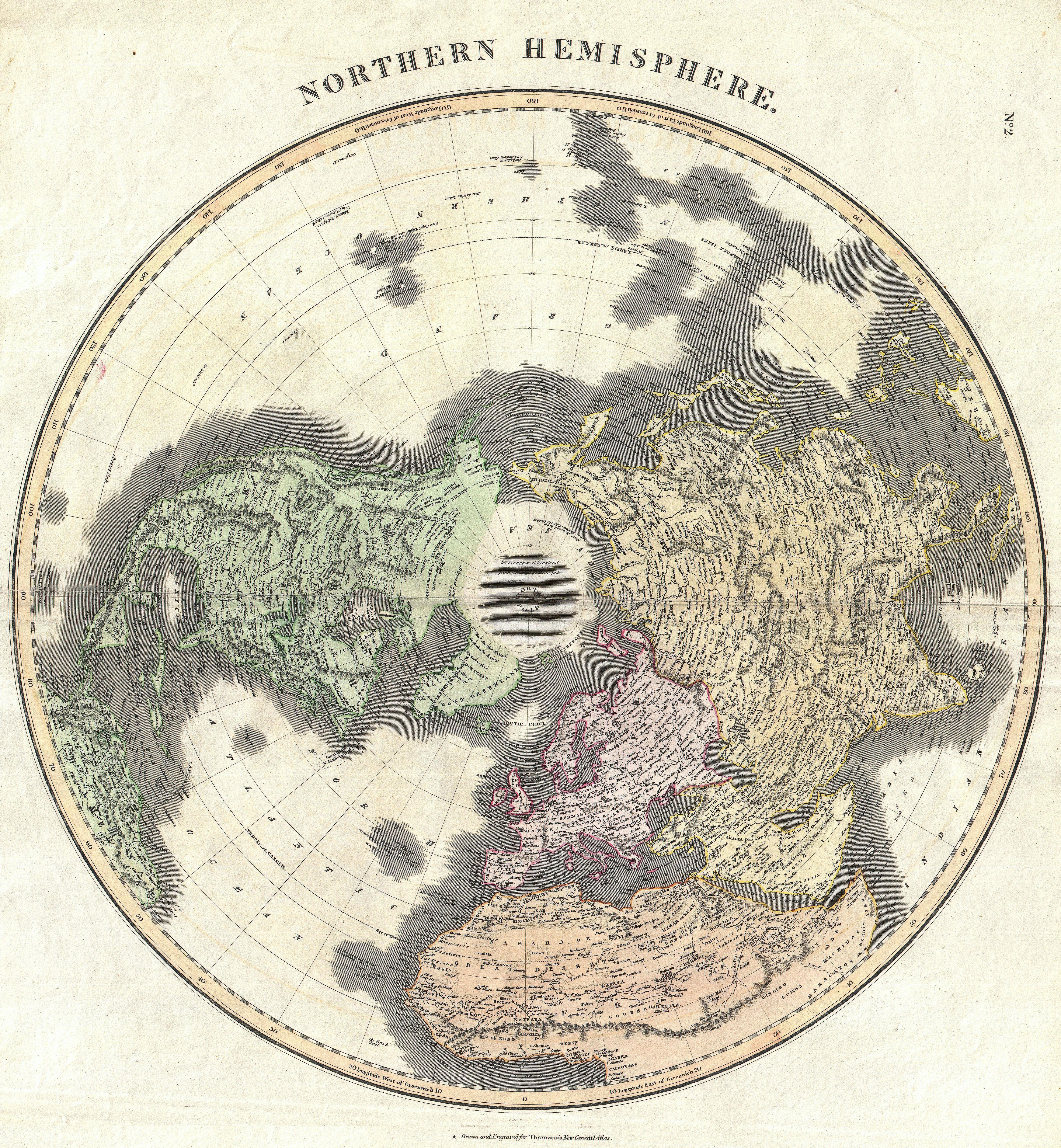
Has anybody found something useful in M. Paulus Ven: lib.1, cap.61 in this regard? Because I did not.
I only found something about the Bargu campestria (plain of Bargu; that's where the name probably originated from) in N. T. Mirov's "Notes On The Domestication Of Reindeer" (pdf, read from "Marco Polo" at p.11) but nothing about the islands farther north.


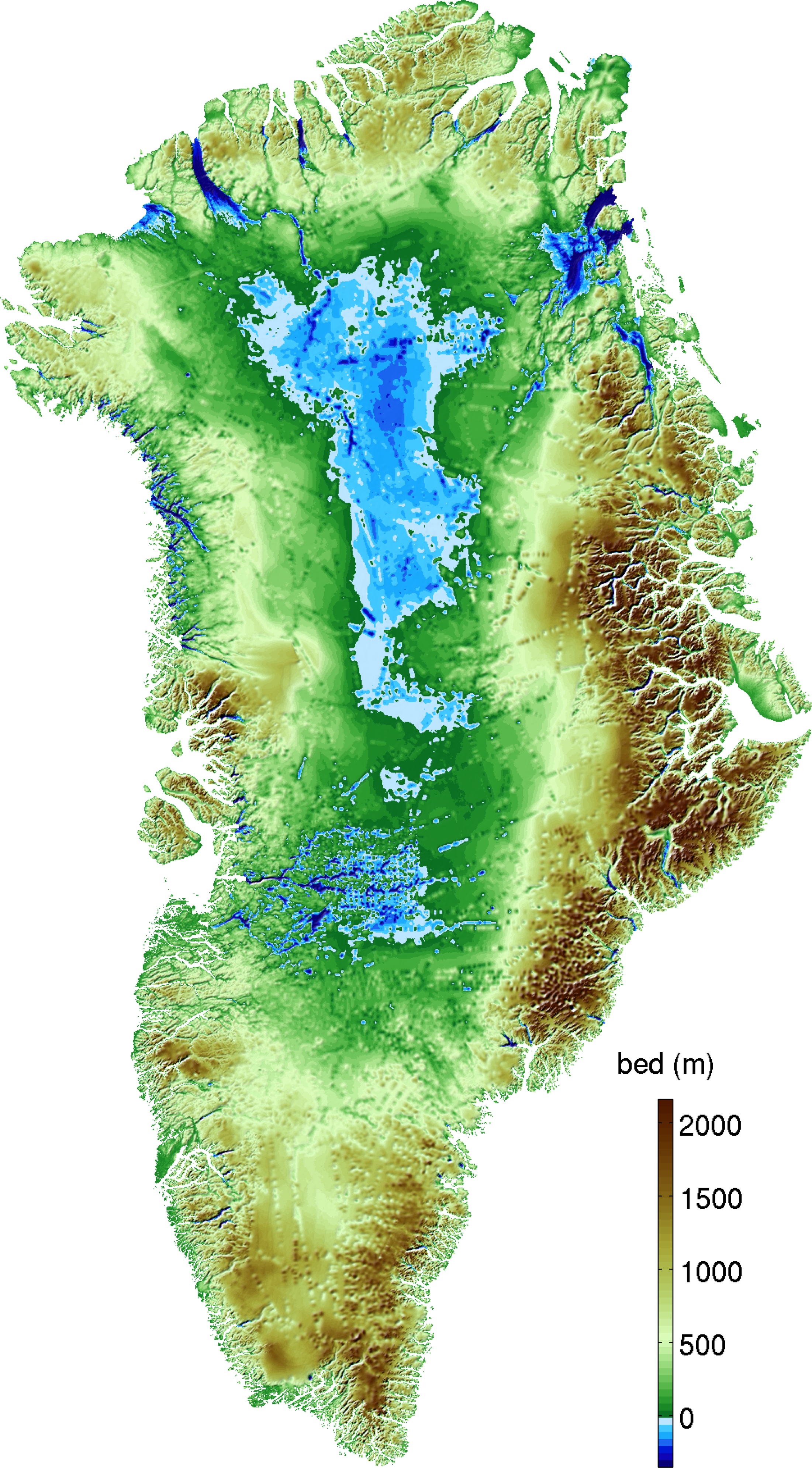
But at least I found some high resolution ocean floor maps showing Greenland underneath its ice sheet:
(all thumbnails lead to the original source)
Image Image Image Image
From left to right:
WORLD OCEAN FLOOR -- John B. Garver Jr., John Shupe (1981, National Geographic Society) [.sid, 47mb]
THE FLOOR OF THE OCEANS -- Bruce C. Heezen, Marie Tharp (1976, American Geographical Society) [.sid, 16mb]
ARCTIC OCEAN FLOOR -- Heinrich Caesar Berann (1971, National Geographic Society) [.jp2, 17mb]
ARCTIC OCEAN -- Heinrich Caesar Berann (1971, National Geographic Society) [.jp2, 17mb]

In order to view .sid and .jp2 files you can use ERDAS ER Viewer 2014 v14.01 (29 MB)
The official download website requires registration but here is a direct download link from the Spanish Instituto Tecnológico Agrario.


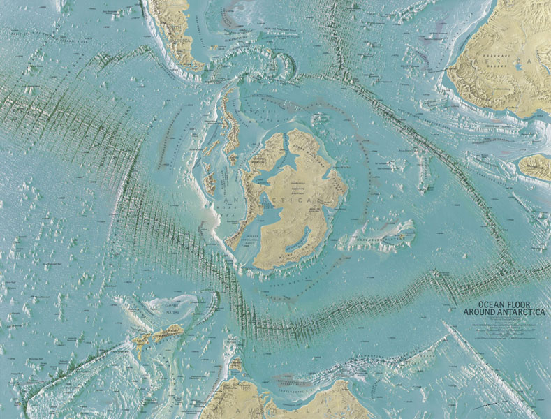
Here is the OCEAN FLOOR AROUND ANTARCTICA (ca. 1972) and the ocean floor globes (1979) all done by H. C. Berann:
(I couldn't find them in high resolution)
Image Image Image Image
----------Antarctica------------Atlantic Hemisphere-------Pacific Hemisphere--------Pacific Hemisphere 2
The collaboration with the national Geographic Society also lead to maps of the ocean floors starting in 1966. In co-operation with the pioneer of oceanography Prof. Bruce Heezen of the Columbia University, NY, and his assistant Mary Tharp maps of all the ocean floors were created. This co-operation culminated in the famous World Ocean Floor map done in 1977 for the Columbia University and the U.S. Navy. (http://www.berann.com/panorama/index.html)

Now back to the Bargos Islands:
The left thumbnail below leads to the familiar Mercator map WITH a search function.
Image Image
The right one is a map from Matthias Quad from his atlas Geographisch Handtbuch which he published with Bussemacher in 1600. The map is right between the pages 77 and 77a which have written a German text on them titled Nordt Polus.
I can barely read the old German text and the "Fraktur font" doesn't make it any easier... Before I start giving myself a headache with this, I wanted to ask daniel if he is familiar with these two pages and perhaps has already seen an english translation somewhere. Would definitely save me some time.

btw I found out about Matthias Quad's map after seeing this 1997 lecture (58min) by Harry Hubbard and Paul Schaffranke. They also showed the oldest map of atlantis as well as two old hollow earth illustrations.
Image Image Image
Question regarding the (upsidedown) atlantis map: Is that what later came to be the Bargos Islands?

daniel, in your paper there is a vignette picturing the four islands (the one where you wrote the names of the islands). Where did you find this vignette?

animus
Mage
Mage
Posts:107
Joined:Fri Feb 20, 2015 10:00 pm

Re: The Bargos Islands

Post by animus » Mon May 23, 2016 9:46 am

Here's another map showing four islands at the north pole, from Johannes Ruysch (1507):
Image

Here are some translations about the north pole from Quadus' map (starts at 1:03:30):
https://www.youtube.com/watch?v=6Wbn_1oHWTc&t=1h3m30s
Looking at the counter, this video has been seen a lot. I doubt that this is new information to the members of this forum but I'm not really familiar with the topic of the hollow earth yet, so I thought I'd post what I've found so far.

Here is a high resolution picture of the Accurata Utopiae Tabula depicting the Schlarraffenland (engl. Cockaigne) if that's of any relevance and not just entirely fiction:
Image

User avatar
daniel
Professor
Professor
Posts:886
Joined:Sat Nov 17, 2012 6:33 pm
Location:P3X-774
Contact:

Re: The Bargos Islands

Post by daniel » Mon May 23, 2016 12:32 pm

animus wrote:I can barely read the old German text and the "Fraktur font" doesn't make it any easier... Before I start giving myself a headache with this, I wanted to ask daniel if he is familiar with these two pages and perhaps has already seen an english translation somewhere. Would definitely save me some time.
Yes, I used that map to calculate the size of the world. I did find a translation at one time, but can't seem to find it again. The text is Latin and online translators do a pretty good job with it. The font isn't too bad and that cane-like letter is actually the old-style "long S." And a small slash at the end of a line is a continuation, so merge the word before it with the word on the next line.

I had not run across this site--much better resolution maps than the ones I have. Good find.
animus wrote:Question regarding the (upsidedown) atlantis map: Is that what later came to be the Bargos Islands?
No. Most of the Atlantis maps are based on solely on the comment that they were beyond the Pillars of Hercules and therefore in the middle of the Atlantic ocean. You've seen the ocean floor data--no evidence of a continent there--but plenty of stretch marks! Look up SIMA (ocean) and SIAL (continent) crusts--different densities and mineral compositions.

Remember that the planet was smaller by some 5000 miles, so the land beyond the Pillars of Hercules (Gibraltar) is North America. They never realized the mid-Atlantic ridge expanded so quickly.

Let me also point out something I left out of the paper is that on these old maps, 0-degrees longitude, the Prime Meridian, does not go through Greenwich, England but down along the east coast of Greenland, which had been attached to the east coast of America--pretty much crossing the area we now know as Washington, DC. Why do you think that region was SO important to the "New World" order?
animus wrote:daniel, in your paper there is a vignette picturing the four islands (the one where you wrote the names of the islands). Where did you find this vignette?
Good question... the original is missing from my "maps" folder. Based on the low resolution, it was probably a vignette from the corner of another map. I'll have to look around.
Power out? Let's see if many hands can make the lights work.
Facebook: daniel.phoenixiii

User avatar
daniel
Professor
Professor
Posts:886
Joined:Sat Nov 17, 2012 6:33 pm
Location:P3X-774
Contact:

Re: The Bargos Islands

Post by daniel » Mon May 23, 2016 1:00 pm

I was flipping through some of the maps on the Rumsey collection, and found this one:

1679 Polar Regions (Sanson)

It shows the Bargos Islands transforming into modern Greenland, where northern Greenland is still at the Arctic pole and the bottom half is freezing over into the conventional map view. Pretty cool.
Power out? Let's see if many hands can make the lights work.
Facebook: daniel.phoenixiii

User avatar
Lozion
Adept
Adept
Posts:483
Joined:Tue Jul 23, 2013 11:32 am
Location:Changes all the time..

Re: The Bargos Islands

Post by Lozion » Wed May 25, 2016 12:12 am

So daniel, why haven't you been to inner Earth yet? I remember your reference to finding "a way across the mountains" for humanity from a few a years ago thinking that was what you meant..
In rapport we thrive, in rivalry we strive.

User avatar
daniel
Professor
Professor
Posts:886
Joined:Sat Nov 17, 2012 6:33 pm
Location:P3X-774
Contact:

Re: The Bargos Islands

Post by daniel » Wed May 25, 2016 11:05 am

Lozion wrote:So daniel, why haven't you been to inner Earth yet?
As I've mentioned, I have friends in low places! :D
Lozion wrote:I remember your reference to finding "a way across the mountains" for humanity from a few a years ago thinking that was what you meant..
I believe that was going between alternate timelines, when seen as valleys separated by mountains.

Unfortunately, most of the routes back (for the body) have been closed off by our good friends in the New World Order. The last thing they want is humanity to wake up.
Power out? Let's see if many hands can make the lights work.
Facebook: daniel.phoenixiii

animus
Mage
Mage
Posts:107
Joined:Fri Feb 20, 2015 10:00 pm

Re: The Bargos Islands

Post by animus » Sun Jan 29, 2017 9:54 pm

Two weeks ago I downloaded the bedrock & bathymetry maps of Greenland along with some old maps from the 16th and 17th century. I was not done looking for maps when suddenly I was without Internet for two weeks. I thought that I'd just do a comparison in the meantime with what I got to get some orientation on the bed maps, see attachment. It's a purely visual comparison. I didn't have maps in high resolution to compare the names of the places.
Here are the raw bed maps that I found:

1)Image 2)Image 3)Image 4)Image
The red contour on the 3rd map is at 0m (=sea level).

Sources:
1): http://sites.uci.edu/morlighem/dataprod ... greenland/
http://nsidc.org/data/IDBMG4# (ftp*)
2) & 3): http://www.the-cryosphere.net/7/499/201 ... ssion.html
http://nsidc.org/data/docs/daac/nsidc00 ... ss.gd.html (ftp*)
4): https://en.wikipedia.org/wiki/Greenland ... edrock.jpg
*Access to data via FTP for this data set will no longer be available after January 31, 2017. The NASA NSIDC DAAC is transitioning to data distribution through HTTPS, which requires users to login with an Earthdata Login username and password. Data will continue to be available free of charge.


Here is my visual analysis:
Comparisons.zip
(1.32MiB)Downloaded 1978 times

Some notes:
Grocland: I'm not too sure about Grocland but I find the positioning of it more likely than the one of Disko Island.
Frisland: The resemblance is remarkable, there is no denying it. It's even still on the same latitude. The Thomson Map of the Northern Hemipshere (1814) also places Frisland at the south tip of Greenland. I didn't know what to make of the south west tip but the error map is red on that spot anyway, so I don't bother.
Severnaya Zemlya: The archipelago wasn't recorded until the 20th century, so my guess is that it was part of what I marked #1 of the Bargos Islands and broke off during the shift somehow. That island is missing some land mass anyway since the river delta next to it is far bigger than the old maps indicated.
Svalbard (Spitsbergen): Macsin of islands and S. Hugo Willoughbes land must have collided and the east part of both of them ended up being today's Svalbard. It's difficult to say which part is which. There was a map published by Moses Pitt (1680) where the west part of Svalbard resembled the east part of Macsin of islands but it doesn't fit the bedrock data.

For convenience's sake I added a contrast of the arctic circle then and now.

Now that I'm back online again, I find that there are numerous old maps of Greenland, many of which are contradicting each other, especially in the south part. The shifting of the whole land mass in the north pole region downwards definitely caused a lot of confusion.

Another thing I found was that there was once a passage from the east to west coast before everything froze over, see the following maps: [1], [2].

edit:
The URL of the first picture didn't work anymore, so I exchanged the picture. I found one with a far higher resolution, so I took that. There is only a slight difference in the center of the map (the subzero region), but nothing major. My layman analysis still holds. And here is another cool graphic:
Image
Credit: J. Bamber, University Bristol

User avatar
daniel
Professor
Professor
Posts:886
Joined:Sat Nov 17, 2012 6:33 pm
Location:P3X-774
Contact:

Re: The Bargos Islands

Post by daniel » Mon Jan 30, 2017 4:48 pm

animus wrote:Another thing I found was that there was once a passage from the east to west coast before everything froze over, see the following maps: [1], [2].
Great stuff... I love old maps.
Power out? Let's see if many hands can make the lights work.
Facebook: daniel.phoenixiii

animus
Mage
Mage
Posts:107
Joined:Fri Feb 20, 2015 10:00 pm

Re: The Bargos Islands

Post by animus » Tue Jul 04, 2017 10:58 am

Several things to update on:

Firstly, to answer my own question about what I mistakenly called a "vignette", it was taken from the bottom left corner of the Mercator world map of 1569, titled Nova et Aucta Orbis Terrae Descriptio ad Usum Navigantium Emendate Accommodata. Here is the composite:
Image


Secondly, I found another old map showing Greenland without its ice sheet. It is the first ocean floor map of the entire globe ever published (taken from LIFE magazine, 7. Nov. 1960):
Image


Thirdly, I thought I would give you the comparison of Frisland without my markers in the way:
Image

Here is a comparison between Frisland and Iceland put to scale. Frisland seems rather tiny compared to the old maps, doesn't it?:
Image

Image


Lastly, there is a passage in daniel's paper that needs some minor correcting:
The Colonization of Tiamat V, p.39 wrote:With that known, we can now identify who’s who and what’s what on the old 1604 map. The land left of Groenlandt across Frecum Danis is Newfoundland. Mare Glaciale is Baffin Bay. Schetlac Island would be the Faroe Islands, Scotia is Scotland, Eislandt is Iceland, and off to the left, Hic Mare est dulcium aquarium is Hudson Bay.
The land left of Groenlandt across Frecum Danis is not Newfoundland but Baffin Island. You can see it clearly in the Mercator world map of 1569. Newfoundland is further south. The error was probably made due to the position of the Hudson Bay which has changed a bit in the last four centuries, or rather it was the movement of the land around it. And yes, it is the Mare dulcium aquarum (Sea of sweet waters).

Schetlac (it actually says Schetlãt with what looks like a vertical tilde; there was probably not enough space for the "n" anymore) is not the Faroe Islands but, as the name would suggest, the Shetland Islands. For a better depiction of Schetlant Insulae you can look at the top left corner of the same map and compare the names: Bresse (Bressay) and Scalwey (Scalloway). The bottom left corner also shows Farre Insulae, the Faroe Islands. And for anyone interested, there is a far more detailed map of the 17th century on the Faroe Islands by Lucas Debes, 1673.


And on a very last note: in two years we will get some new data on Svalbard.

Post Reply